History of Bronnitsy
–Ь–µ—В–Ї–Є: bronnici вАҐ bronnitci вАҐ bronnitsy вАҐ city вАҐ description вАҐ English вАҐ golden ring вАҐ history вАҐ moskow oblast вАҐ photo вАҐ ramenskoe region вАҐ rewiev вАҐ russia вАҐ small town вАҐ town
The first written mention about village Bronnichi refers to 1453. But¬† location of the village — halfway between Moscow and Kolomna — major trading cities of the time, suggesting that the village appeared much earlier than it says about the official documents¬† ( In 1453, Grand Duchess Sophia, the widow of Prince Vasily Dmitrievich I ,¬† bequeathed Bronnichi with other villages to his grandson Yuri Vasilyevich. Archaeological research has shown that the area near Bronnitsy, was inhabited in the XI century. In the XII century there existed a Brasheva fortress which is protecting Moscow from the south.)
In XV-XVI centuries, is formed radial structure of settlement in the territory of modern Moscow region along the traiding paths, linking Moscow with the principalities of Russia. So, development of Bronnitsy is inextricably linked with the development of the Moscow region.
For a long time, the village Bronnichi was royal estate. At the end of XVII century here was one of first stud in Russia. Later the village became a major center of horse breeding palace because  of great meadows along the coasts of the Moscow River, and lake Belskoe. Also Bronnichi village supplied Moscow hay and various agricultural products.
The main commercial route of¬† XVIII century was the Moscow River, the second route — Kolomenskaja road. Bronnichi was situated at intersection of Kolomenskaya and Kashira roads. Formation of city planning structure subordinate to the main transport routes passing through Bronnitsy. Even in the planning of the old city main axis is the¬† road «Moscow-Kolomna», held by the modern street «Moskovskaya».
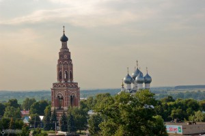
The second most important road of the those times was Kashirskaya road; This road from Kashira became into the street, going to the main square of the city and then go to the cost of Moscow River. The main square of the city was formed, as i wrote before, at the intersection of Kolomna and Kashira directions. On it in 1705 was buid a brick five-domed Cathedral of the Archangel Michael. Significant size and expressive scope of the cathedral still dominated over the territory of the city. Near the cathedral there were public buildings and Seating yard. North-east of the main square was Konyushennaya settlement associated with the nearby equestrian yard. Stables occupied a large territory to the east of the residential neighborhoods and included stables, fitting the yard, riding school, Konyushennaya office. Farther south, an area with Rye Treasury Court and the barn was conducted trade in grain.
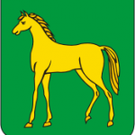
Catherine II’s decree on October 5, 1781, to create a new administrative division of Russia. Bronnitsy became county town and the center of the newly formed Bronnitsy district, Moscow province. Also Bronnitsy received a new regular town plan and the emblem, which was a golden horse on a green field. Like all plans of cities, developed by the «Commission for the buildings design», plan of Bronnitsy in 1784 was aims to create a unified urban ensemble: geometrically regular layout of the blocks network with composition of integrated streets and squares. Simultaneously the project took into account the specific nature of the city, located on a busy commercial thoroughfare, and historical topography of the city.
The project was supposed to expand and straighten the streets. The main street was scheduled Bronnitsy north of the Ryazan road on Gentry Street (Sovetskaya str.). The second value remained the street Kashirskaya (modern Kashirskii lane.). The principal axes of the city planning structure has been strengthened in pairs symmetrically located: Arkhangelskaya and Moskovskay, Anisimovskaya and Salnikovoi Street (modern: Krasnaya and Moskovskaya street, Pioneerskii and Octyabrskii lanes). The Project in 1784 suggested the development of many squeares, «threaded» on the main street of the city.
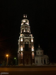
Organization of the central square with a perimeter of an orderly development should emphasize the importance for the town existed already dominant — the Cathedral of the Archangel Michael. The value of the main square has been strengthened in the nineteenth century … Here were built: the vicinity of the cathedral — the Jerusalem church and the 80-meter bell tower in the southern part of the area — Seating yard. Cathedral Group of the temple complex dominated the city and the space has subjected the central square, the size of which is 200 √Ч 240 m. A more modest vertical dominant church of the Assumption of the Blessed Virgin appeared later in the nineteenth century. on the western outskirts of the town cemetery at the entrance to Bronnitsy from Moscow. A significant impetus for the development in the city served placement of Cavalry Regiment at the turn of XVIII and XIX centuries.
Three of the dominant — the church at the entrance, the temple complex with a bell tower in the center and the building of barracks in the eastern Bronnitsy located along the compositional axis of the city, running parallel to the axis of the landscape and has the orientation of the north-west to south-east along the valley of the Moskva River. Major transport direction from Moscow, Kolomna and Kashira outlined in the plan XVIII., At the entrance to the historic city-oriented Catholic group in the center Bronnitsy. But the plan of «Commission for the buildings» was not implemented fully. Was not carried out the construction of square at the south of compositional axis at Kashirskii lane. Buildings main square was formed in the nineteenth century but only partially complete.
The beginning of the nineteenth century. was a period of prosperity of the city Bronnitsy, through which horse-drawn carts and waterways, are getting rich and becoming a major trading center. The city is intensive construction of stone buildings. The town was trade, it emerged hotels and inns. In addition to the highway Moscow-Kolomna and Moscow River the city received a new transport direction — the road to Bogorodsk and Podolsk.
The railway, built in 1862, was 11 km from Bronnitsy (nb There is a legend that the merchants g.Bronnitsy specifically lobbied the building of a railroad in the side of the city, that city remained remain calm and quiet), and this reduced the potential for industrial development of the city.
In situational plan of Bronnitsy of 1873 clearly traced the role of natural factors in the formation of its planning structure: Chizhov ravine that crosses to the west, and the gully region. Kozhurnovki the east side of the city. Ravine area formed a two-expressive «poluskoby» in the natural landscape of the city.
Bronnitsy second half of the nineteenth century have left any significant and of historical and architectural value of public works.
By the mid-twentieth century. Functional planning structure of the city has undergone little change, reaching the southern and western boundaries of the regular plan of 1784.
At to 50-th years of the twentieth century preservation of the cultural heritage of the citywas not a priority for urban development. So at the coastal zone of the lake Belskoe and river Moscow were constructed large objects for special purposes. By that time, actively began to explore the territory east of the river Kozhurnovkoy. It was built the road A-107 «Ryazan-Kashirskoye» — a modern street Tolstoy and its western extension to the boundary of the city. Over time, the central part of the city Bronnitsy was semicircle in industrial areas.
Intensive development of building various applications along the concrete strip, due to the presence here of availability of land, as well as stimulated by transit traffic through Bronnitsy, led to the formation of a new frame element in the planning structure of the regular city — a powerful arc, connected the street Sovietskaya and Kashirskii lane.
In 1992 Bronnitsy became a town of regional subordination, and the new city limits, according to which the area of the city increased from 600 ha to 2216 ha. Bronnitsy significantly expanded its borders, including a free territory in the north-west, south and south-west of the village Menshov and Marino. During the years of Soviet power in existing industrial and defense systems, having in its composition research institutions and testing companies, which today contribute to the establishment and improvement of military equipment for the Armed Forces. Important not only for the city, but the whole country is Bronnitsky jewelry production, leading back to 1924 from the farm «Metalist».
With all the spatial transformations that have occurred in the past two centuries, the historical stability Bronnitsy distinguish regular layout. Since the end of XVIII century and to nowadays the central part of town was developed through the regular Plan 1784 Entire implement his ideas and save them as a whole so far is a shining achievement of Russian urban development.
Regular planning in Bronnitsy is connected with terrain profile. The city is situated on a low terrace above the valley of the Moskva River, which has a gradual increase in a south-westerly direction with 20 to 60 meters difference.
Today Central Square of Bronnitsy is still the urban center — it has shopping, entertainment and administrative buildings. Kashirskii lane turned into the main entrance to the city center from the south. Lanes perpendicular to the main street, oriented to the lake.
The originality and individuality of appearance and layout Bronnitsy are combined regular network of streets and picturesque ravine areas flanking the central part of the city.
In the process of historical evolution distinctive silhouette and a panorama Bronnitsy, most clearly perceived from the Moscow River.
The combination of the main elements of the architectural and spatial arrangement of the city — the temple complex and its subordinate buildings providing extremely vivid expression landscape of the Bronnitsy.
See also — Photos of Bronnitsy
–Р–і—А–µ—Б –і–ї—П —В—А–µ–Ї–±–µ–Ї–∞ | Comments RSS
